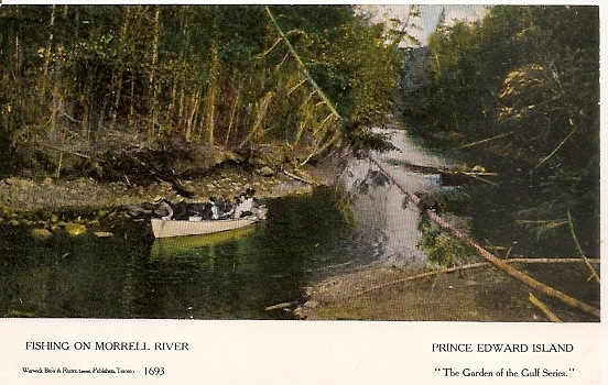
The Morell River River, although short by non-Island standards, is one of the few remaining salmon streams in the Province and also has a good resident trout population. Although not easily accessible by land, it could be traversed by riverside paths and canoes – at least until post-tropical storm Fiona blew hundreds of trees down blocking the river. During the golden age of postcards the Morell could be easily reached by rail and it is not surprising that it appeared on a few early postcards.
It seems to be a typical photo of the period, perhaps one of the dozens taken by Charlottetown photographer, W.S. Louson who provided many images for postcard publishers Warwick and Rutter of Toronto including several of the Dunk River near Summerside.
However in looking closely at the image something looked a little bit off. I have fished much of the Morell and cannot recall seeing anywhere where the bank was exposed just like that … and those were pretty suspicious looking rocks. However I chalked it up to my imperfect memory until I saw a November 26 2023 posting on the very useful Nova Scotia Postcard Collectors Facebook page from collector Scott Isenor. Scott had posted a Nova Scotia card with the Morell image but with a different location:
His posting also contained a number of Crawley Creek cards which confirmed that the Sydney location was correct and that the river was most assuredly not the Morell.
While Warwick Brothers & Rutter were not the only firm to use the same cards for multiple locations it happened too frequently for it yo be simply a filing accident. I have written about several other W&R mis-locations in previous postings. A P.E.I. fishing scene was appropriated for use as the Humber River near Toronto as seen here, and, perhaps in a spirit of atonement, an Ontario waterfront became confused with Charlottetown Harbour here. Another double location card (shown above) is variously titled “An Evening on Blair’s Lake, Amherst and Sailing near Holman Island, Summerside Harbour.”
However Warwick & Rutter were mere amateurs in the duplication of locations as seen in this post and this one
When we think of marketing postcards the image of the postcard rack with dozens (or sometimes hundreds) of cards available for sale. Even the few photos of historic postcard shops, such as the one of the McCoy shop in Charlottetown, seen below, reinforce this perception of single card sales. Certainly the fad of postcard exchanges with their associated albums seems to be based on the sale of individual cards , or perhaps packets of a half dozen or dozen individual cards.
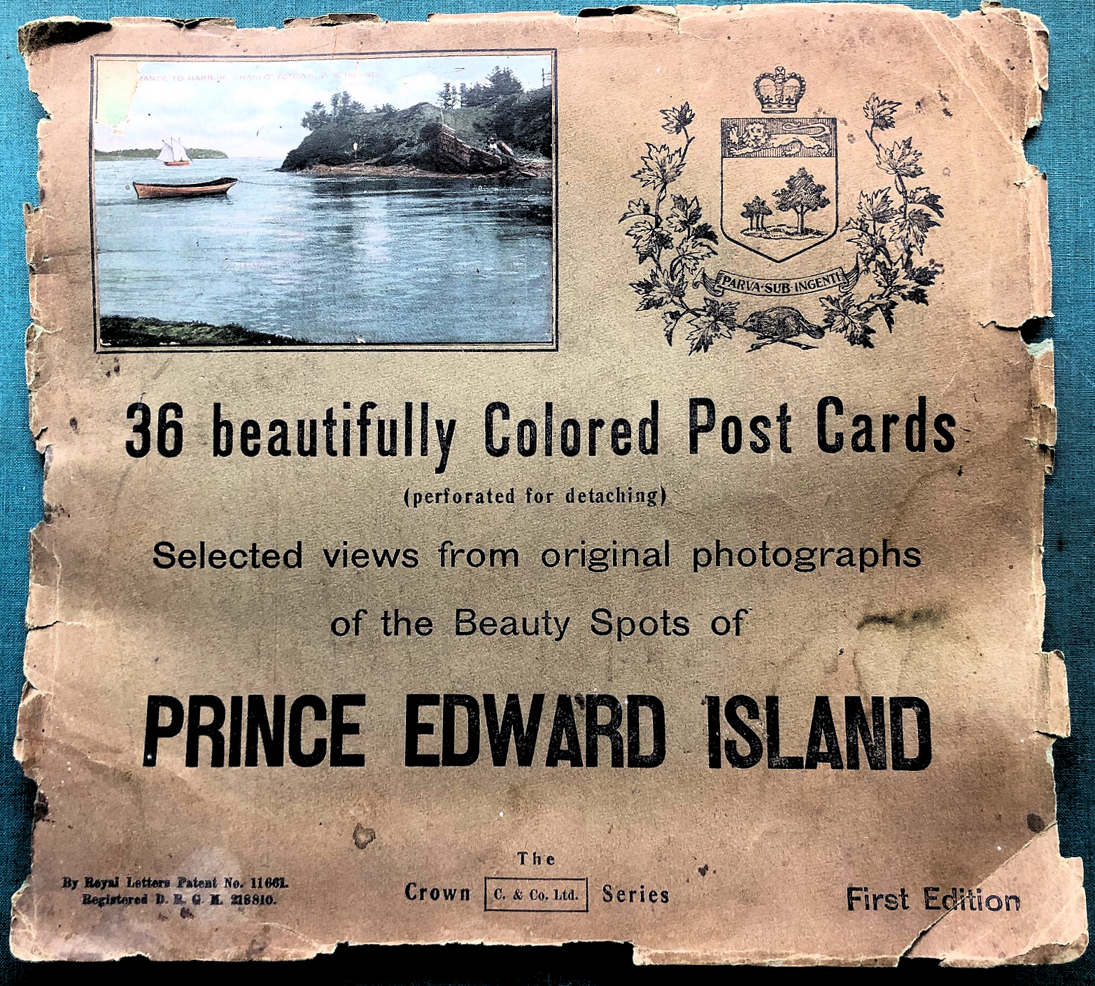
The possibility of multiple card sales arises however as it is noted that some cards seem to have one or more perforated or serrated edges. Such was a the case with several of the cards in my collection of early PEI cards with the imprint of Cater and Company (C & C Ltd.), especially with what I have chosen to call the “Red letter cards.” These “Souvenir Mailing Cards” appear to have been printed by the Toronto company Nerlich and Company. I have been able to document some thirty-six of these cards but have had no way of knowing if this is the complete run of images.
This and other questions about these cards was answered when I acquired a very beaten-up and damaged copy of a publication. Although somewhat cockled and water-damaged it is clear that the package was complete. Measuring some 29 by 26 cm The publication contained six pages stapled inside covers.
Inside the six pages each contained six standard sized images “perforated for easy detaching” and amazingly none had actually been detached. Collectively the album contained the entire series of “Selected views from original photographs of the Beauty Spots of PRINCE EDWARD ISLAND.” Many of these images were already published in other card series, especially those photographed by William Steel Louson.
A typical page shows an almost random placement of the cards with vertical and horizontal cards on the same page. Closer examination revealed the perforations between the cards making it easy to remove any or all cards.
The reverse of the postcard pages shows the standard back used by Carter and Company for their cards in this series.
The listing of thirty-six images suggests that this is the complete press run of the series which seem also to have been printed as machine-cut individual cards and so it appears that I have a complete set of the individual cards as well as this compilation. It is likely that this publication was prepared by Nerlich as a marketing aid. I am not aware of any other sets in this format but it is likely that other Nerlich cards were sold in this fashion. However, with its perforated pages the item was designed to be destroyed, making this item, deformed and damaged as it is, a rare survivor.
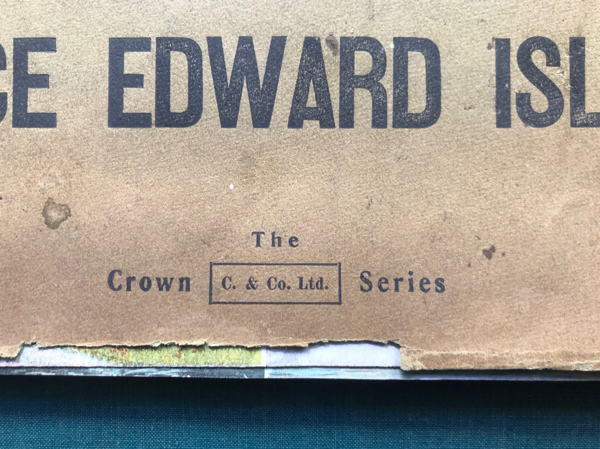
As I noted on my earlier posting of the Carter & Co. cards there are also a number of cards from the Crown Series which, although similar in format and hue, have a slightly different back. One of the anomalies of this publication is that this portfolio itself is noted as being “The Crown Series”
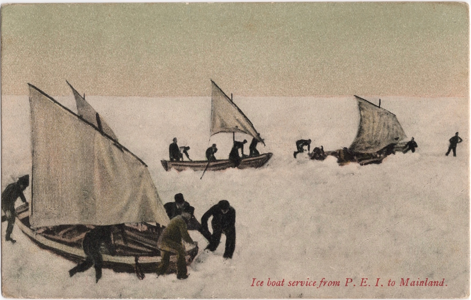
Ice Boats crossing from P.E.I. to the Mainland. Publisher not identified. ca. 1907 Image courtesy Phil Culhane. peipostcards.com
Early postcards used a variety of available images and the photographers are very rarely identified. While some card series do specify the photographer it was not common practice. Moreover even if a photographer is occasionally identified the same image may be reused by the same or another publisher with no credit given. In the postcard mania period before 1910 publishers grabbed images where ever they could find them and any photographs available to the public seemed to be fair game without credit or remuneration being given.
It is always gratifying to put names to images. Such is the case with regard to the undated card shown above. This early divided-back card shows a dramatic scene with crews struggling to bring iceboats across a field of jammed ice or thick “lolly.” Unusually the boats are show with their small lug sails in use. These were only deployed when wind speed and direction were favourable. The photo is not particularly crisp and the quality of the reproduction poor but it is one of the earliest postcards to show the scene which was unique to the winter service on Prince Edward Island.
In researching the history of the iceboat service I stumbled across the same image, hiding in plain sight, with the identity of the photographer credited. In April 1903 the Prince Edward Island Magazine published an illustrated article titled “Our Winter Navigation.” (available here) The illustrations consisted of images of the winter steamer captains and several shots of the iceboats and crews in action. Unlike some iceboat photos of the period these are not posed groups but action shots of the crews at work. These photos were most likely taken during the winter of 1902-1903.
Frontispiece. Prince Edward Island Magazine April 1903
Here as the frontispiece for the issue is the postcard photo but with the photographer identified – W. Erdley Hyndman. Walter Erdley Hyndman (1875-1936), was connected with a family with shipping and marine insurance interests although he does not appear to have been a member of the firm that continues today has Hyndman & Company. Instead he trained as a civil engineer and for more than thirty years worked as a district engineer with the provincial Department of Public Works.
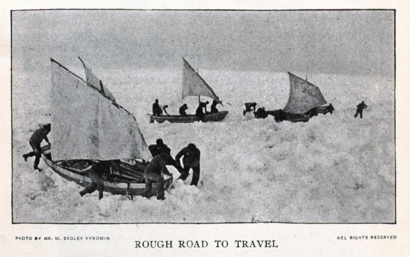
This was not the only W. Erdley Hyndman image in the article to be published as a postcard.
This image used in the article appears as the subject of a 1907 card issued by Charlottetown Booksellers and Printers, Haszard and Moore, although it was not printed by the firm as evidenced by “Printed in Belgium” in the stamp box.
Ice Boat service from P.E.I. to Mainland. Haszard & Moore postcard. Author’s collection.
The article included one other Hyndman photograph – shown below – which does not seem to have been used for postcard purposes – or at least no copy of such a post card has yet been found.
As well, there seem to be other images which may well have been taken by Hyndman the same day which were not included in the Prince Edward Island Magazine article. This is the case with “An Easy Stretch.” Other iceboat cards also appear to have used images which were taken by Hyndman although no credit is given. The card below, “Crossing to Prince Edward Island in Winter,” was sold by Taylor’s Bookstore and given the style, title type-face and subject certainly seems to be part of the same series although the card is monotone image.
Coming to Prince Edward Island in Winter. Taylor’s Bookstore postcard. Robertson Library UPEI.
This card too was printed in Belgium and the card back is identical in design save for the name of the firm selling the card which has been changed.
These appear to be the only iceboat postcards for which the photographer is definitely known with the exception of a later series of real photo postcards. Iceboat postcards constitute a thematic subject unique to Prince Edward Island and Northumberland Strait. They will be the subject of a future posting.
Among the excellent resources for post card collectors are the series of guidebooks published by Mike Smith. One of these, The McCoy Printing Company Picture Postcard Handbook 1900 – 1910, by Michael J. Smith and William P. Angley, documents the postcard activities of the McCoy firm which was located in Moncton, New Brunswick. Among the hundreds if not thousands in cards the volume records some fifty McCoy postcards with Prince Edward Island images. Although a few additional P.E.I. cards have been found since its publication in 2009 it remains the “go-to” guide for McCoy postcards. Unfortunately the book is no longer in print and used copies are rare .
The Post Card Shop in Charlottetown circa 1908. Smith – The McCoy Printing Company – introduction
In addition to the illustrated card listing the volume also contains a well-researched history of the company. In the introduction to the volume a photograph of the Postcard Shop in Charlottetown appears with its proprietress Annie McCoy. With its shop window filled with postcards and a distinctive corner location and design I have always been curious as to its location and in fact have been skeptical that it was in Charlottetown at all. Most of the buildings in downtown Charlottetown date from the 1880s and 1890s and some date back to the 1840s. The area has been slow to change and this view, with its street sloping off the the left is not recognizable in the present downtown.
The business itself seems to have been somewhat ephemeral. A newspaper search revealed that an Annie McCoy was a resident of the city around 1908 and an advertising listing noting a sale of sheet music in the summer of that year confirms that there was a store with that name in the city. But was it this store, and if so where was it?
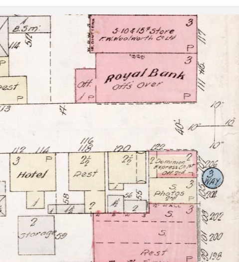
A close examination of the picture shows a placard for Dr. Bagnall, dentist mounted on the corner post. Further newspaper searching revealed a police report of a break in at Dr. Bagnall’s office at the corner of Queen and Richmond Streets. This represented some progress but each intersection has four corners. Which might the store have stood on? At Queen and Richmond one corner was occupied by the City’s Market Square. Two other corners were anchored by well-documented and photographed buildings. On the South East corner stood the Stamper Block which is still there and little changed. To the North West was the London House mercantile establishment, later to be the Royal Bank. Strangely, the South West corner does not appear in photographs and the buildings on the corner, and indeed those of the entire block were razed in the 1950s and became the site of the Dominion Public Building which housed the Charlottetown Post Office and other federal government departments.
Detail of Queen and Richmond corner. Goad Insurance Atlas 1917 edition. Public Archives and Records Office.
While the structure not shown in photographs there is one resource which does depict the buildings before they were destroyed. The Goad Insurance Plans held at the Public Archives and Records Office contain details of all of the buildings in Charlottetown. The 1917 edition shows that the South West corner was occupied by a small wooden, brick veneered, building of two stories, occupied at the time by the Dominion Express Office. Could this be the site of the Postcard Shop? While the slope of the street is perhaps less obvious than in the photo it is noticeable. Because only the ground floor is shown in the picture it is not clear if the building was brick and the view down the street to the west contains nothing which is identifiable today.
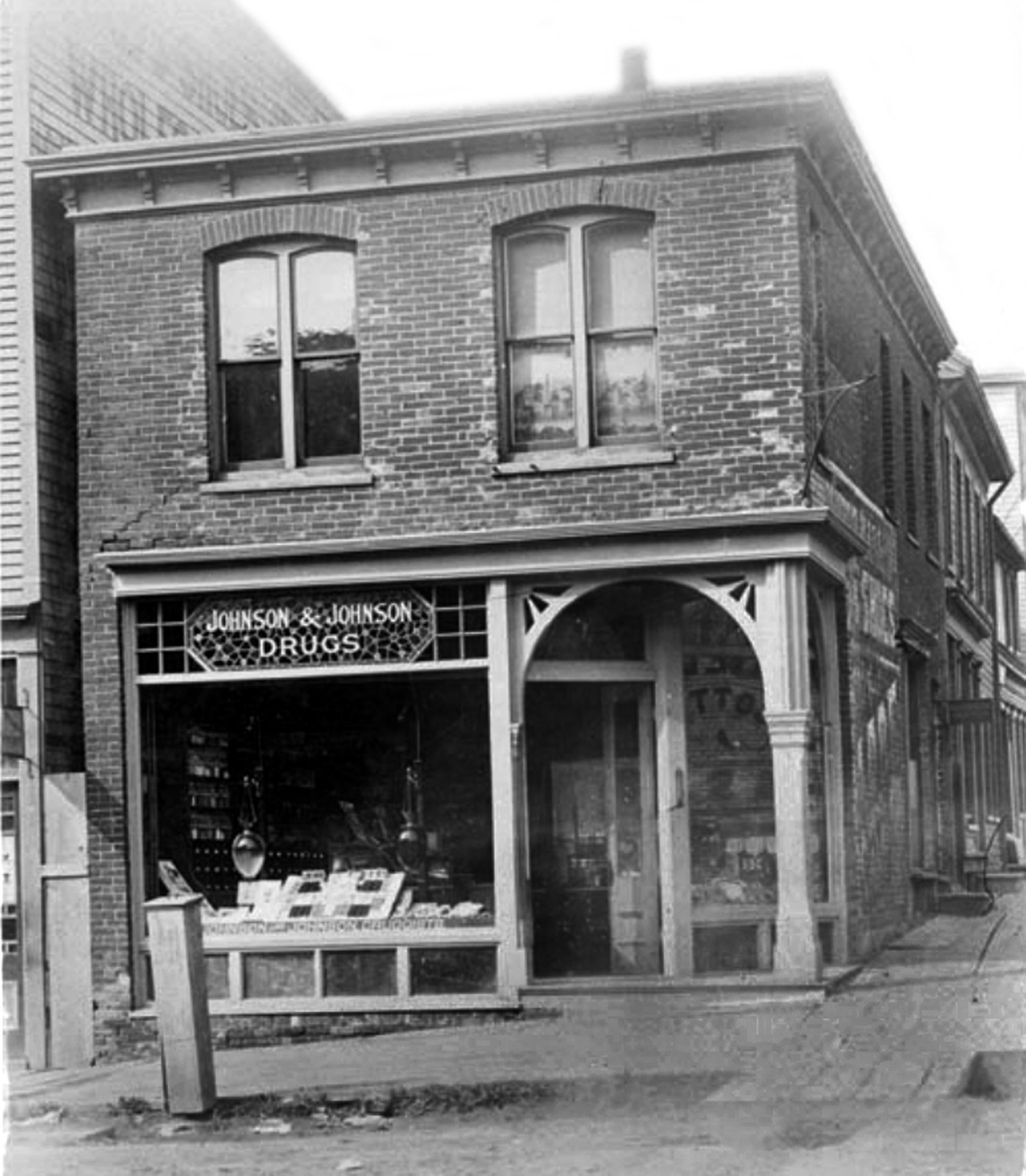
Johnson & Johnson Drug Store ca. 1895. Public Archives and Records Office Accession 3218/75 David Sterling album
The mystery was brought to a close by a previously unidentified photograph in the David Sterling album at the Public Archives and Records Office. This picture, dating from the mid 1890s, shows the building in its entirety and matches completely the details of the building shown in the 1917 plan. In the 1890s it was one of the locations for the Johnson & Johnson drugstore and the site was identified following a discussion on the Earle’s Photo Restoration Facebook Page in 2019. Fortunately there are enough details in the Postcard Store photo to match it to this building. The arched doorway, corner post, and large shop window are common to both images.
While this corner in the centre of downtown Charlottetown was an ideal location, the business does not appear to have been a success. There are no references to it beyond the few mentions in 1908 already noted. Within a few years the postcard mania had waned and many postcard publishers were out of the business before the Great War. In Charlottetown some of the suppliers such as Maddigan, Carters, and Haszard and Moore had postcards only as one part of a larger business operation and although they continued to sell cards it was only a small part of their offerings. Annie McCoy may not had had that option.
Almost as quickly as it appeared, the Postcard Shop seems to had disappeared leaving only one almost forgotten image behind.
When the postcard craze began in the first decade of the 20th century many of the large publishers were hard-pressed to quickly find images of the county in order to respond to the demands from vendors for attractive cards in order to meet consumer desires. Much photography was from local amateurs. In P.E.I. these included W.S. Louson and Cumming Brothers. As we learn more about the postcard trade of the period it is emerging that rather than being commissioned specifically for postcards, many of these images were from pre-existing bodies of work which were appropriated for postcards.
One available source was from the small but growing number of professional photographers who were in the business of producing promotional photography for railway and shipping companies and many of the most memorable images of the period are from the photographic artists engaged by companies such as the Canadian Pacific Railway, Canadian Government Railways, and the Grand Trunk to promote their passenger rail services to the emerging body of railway tourists.
A recent article in the winter 2021 edition of the Toronto Postcard Club’s journal Card Talk by Roger Miller titled ” Who was that Photographer? John Wesley Swan and the Grand Trunk Railway” identifies a previously uncredited photographer of several iconic postcard images of Prince Edward Island. These photographs were not created for postcards but they quickly became some of the most popular views of the province.
Interestingly, J. Wesley Swan (1859-1913) had P.E.I. connections. Although born in Montreal in 1859, the early 1880s found him working in the photography studio of George H. Cook in Charlottetown where he married Annie Morton of the city. He relocated to Norway Maine, which was on the Grand Trunk railway line between Montreal and Portland, where he opened a studio. In 1885 on a visit to visit friends on P.E.I. he was identified as an artist and correspondent for the New York Graphic newspaper. It was rumored at the time that he intended in opening a studio in Charlottetown but this proved to be untrue. His Norway studio was destroyed by fire in 1900 and by 1902 he was living in Montreal.
In 1902 Swan was once again on the Island having been commissioned by the Canadian Government Railway system to take photographs to promote scenery and summer resorts along the line. Roger Miller states that Swan was the official photographer for the Grand Trunk but he appears to have no difficulty taking on a job which benefitted the competition. He was reported to have taken 48 large views on the Island to be used for this purpose and the Charlottetown Guardian enthused that this would result in a large influx in visitors in the following year, noting the positive results of a similar campaign in the Muskoka Lakes region for which Swan had been commissioned to photograph by the Grand Trunk.
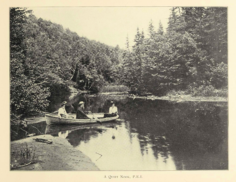
Eight of these photographs appear in an undated publication by Swan which, from internal evidence, appears to date from 1904. This album, Through the Maritime Provinces (New Brunswick and Nova Scotia) By J. Wesley Swan, Montreal includes images which continued for decades afterwards to be emblematic of rural Prince Edward Island. The brief introduction notes “The views shown are reproductions from direct photographs made by the publisher and are only available through this channel.”
Trout Fishing, P.E.I.
Steamer “Northumberland”
Rustico Beach, P.E.I.
A Quiet Nook, P.E.I.
Pownall Bay, P.E.I.
Pastoral Scene
A Country Drive, P.E.I.
Morrell, P.E.I.
Almost all of these images were published as postcards about 1906. Cropped to fit the postcard format, they appeared as two series, both published under the imprint of Valentine and Sons and they all have Valentine image numbers (100219 – 100128) . The first series, in black and white, is a co-publication with the Prince Edward Island Railway, a division, along with the Intercolonial Railway, of the Canadian Government railway system. The second, with coloured images, appears under the Valentine name alone.
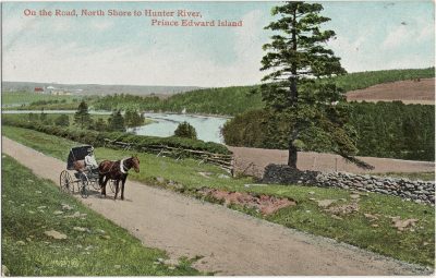
On the Road, North Shore to Hunter River # 100,927
A posting on these two series titled “The P.E.I. Railway postcards of Valentine and Sons” can be found here. It is interesting to note that for the most part the Valentine Card captions are the same as those used for the Swan volume.
Several of the Swan photographs, including the image heading this posting, do not appear to have been reproduced in postcard format but do appear in Intercolonial Railway promotional material. Swan images of P.E.I. do not appear to have been used by other publishers. This was not the case elsewhere where Swan photos are the source of Warwick, Gage and Stedman cards among others. The postcard collectors dream is that with 48 PEI images to start with, there could be other Swan postcards as yet undiscovered.
The 1904 Swan album appears to be the source of dozens of other Valentine postcard images for Quebec, New Brunswick and Nova Scotia as well as the P.E.I. cards noted here. Identical captions shared by both the book and the Valentine card listing (found here) suggest that J. Wesley Swan was one of most important of the early postcard photographers of Canada – and one of the most unheralded.
When the postcard collecting mania developed in the first decade of the 20th century publishers used a vide variety of devices to stimulate sales. Postcards were printed on unusual surfaces including bark, wood and leather; they were embossed or finished in textured surfaces, hand painted or with sparkles added.
One approach was to use unusual sizes for the cards. There were limitations imposed by the postal authorities – sometimes the subject of international agreements – which limited sizes but still some publishers produced cards shaped like bookmarks. I have written elsewhere about the use of the leporello card which incorporated miniature images within a standard card.
Another mechanism was the multiple folded card which came in double, triple or even larger formats providing a panoramic image, sometimes employing special lenses or cameras. It is the folded nature of these cards which helps make them scarce and most of the surviving examples are un-posted. Unless kept closed somehow the cards were vulnerable to damage in the mails. This coupled with the pressure on the “hinge” from opening and closing the card meant that the two parts often became separated and it is not unusual to find half cards. These can appear to be single cards but the presence of an irregular edge can suggest the card was once part of a double or triple image.
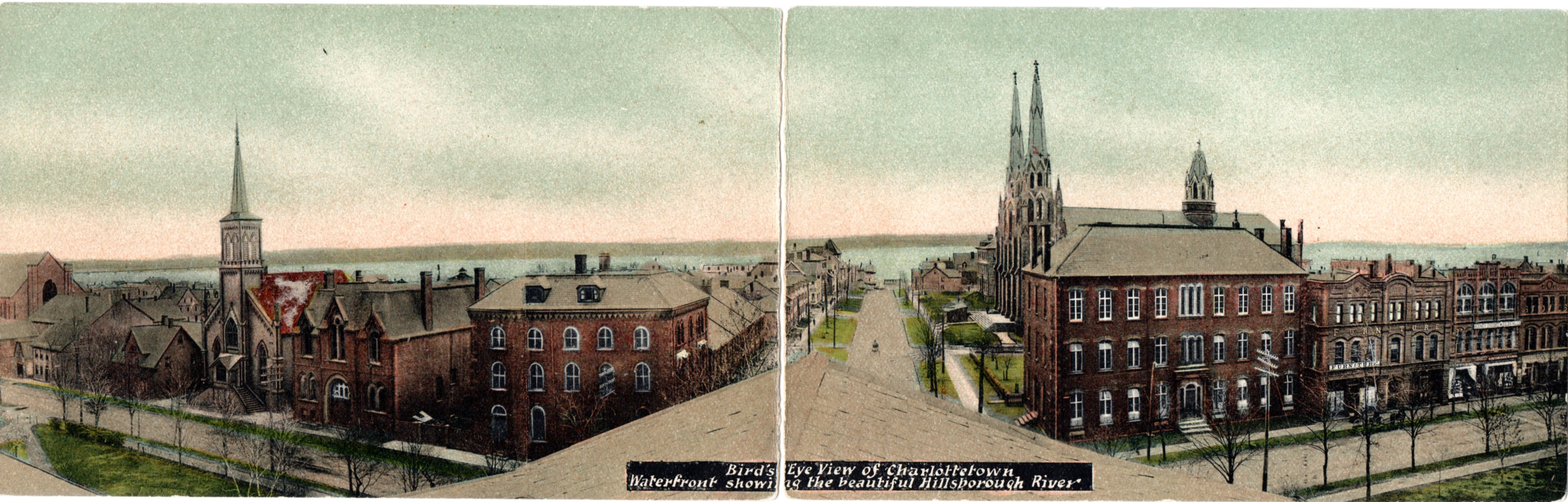
I have been able to find only three examples of a P.E.I. double card from the period before 1930 and they are presented below in approximate order of publication.
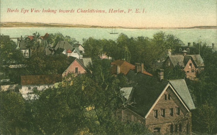
The earliest of these is a Haszard & Moore card which I have previously written about here. The photo was taken from the roof of the Colonial Building, later the Provincial Building and now erroneously called Province House.
Bird’s Eye View of Charlottetown Showing the Beautiful Hillsborough River. Haszard and Moore, Importers
Bird’s Eye View back
Taylor’s Book Store is noted as the publisher of the view below showing the harbour and Victoria Park but, except for the name, the back and the card is identical to the one above and both were printed in Belgium. This view was taken from the roof of West Kent School and the view is toward the harbour’s mouth with the expanse including the large structures on West Street including the Eden House on the corner of Grafton and West, the stone Young house at West and Kent and across from it, but hidden in the trees, is Beaconsfield surrounded by its impressive fence. I am indebted to Phil Culhane who has the premiere site of PEI postcards at http://www.peipostcards.ca/collection/ for providing a copy of this double card to me.
Harbor and Entrance to Victoria Park, Charlottetown, P.E.I. Taylor’s Bookstore
Harbor and Entrance back
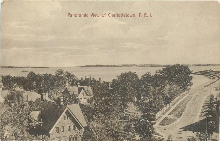
Two related cards appear below which at first glance appear to be merely the right and left hand halves of the double card. However closer examination shows that it is the same image – note the shadows of the Armouries and the vessel at anchor – but it actually shows more than half of the double image and the double has cropped out a considerable portion of the sky. These cards were made using the same images as the double card but are cropped differently.
Panoramic View of Charlottetown, P.E.I. TuckBirds Eye View Looking Towards Charlottetown Harbor, P.E.I., Haszard and Moore
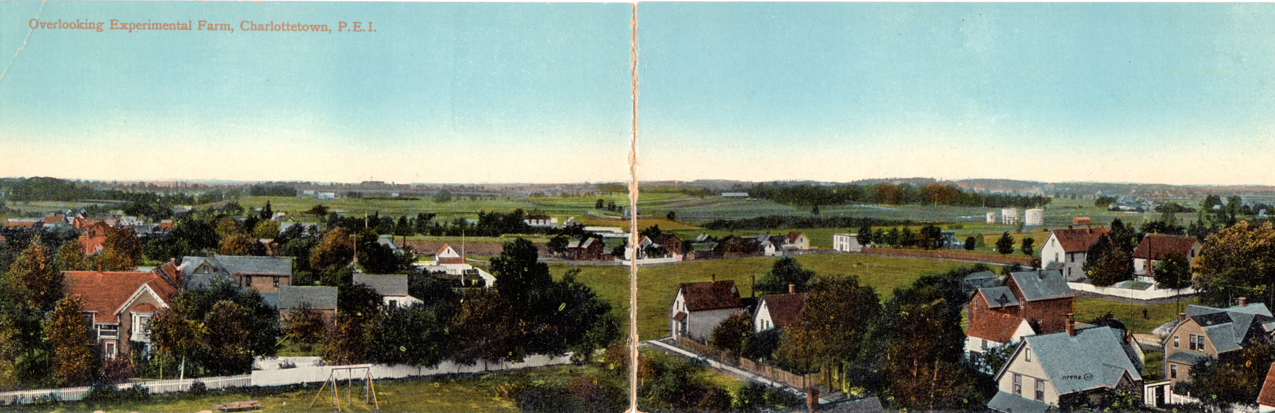
The third double card is a scene looking north from Prince Street School. It depicts a view encompassing the site of St. Dunstan’s College and extending east almost to St. Avards with the lands of the Dominion Experimental Farm featured. This card was produced by Valentine & Sons and appears to be the only double card for P.E.I. in the hundreds produced by that company. I have written additional information regarding this card in an earlier posting found here.
Overlooking Experimental Farm, Charlottetown, P.E.I. Valentine & Sons No. 111402
Experimental Farm back
In order to have a good vantage point for a panoramic card it is necessary to have an elevated structure or natural feature. In Charlottetown, other than church steeples there were few high buildings. As we have seen one view is from the Colonial Building. The other high structures in the city were both schools; The Wesleyan Academy or Prince Street School and West Kent School. Both of these four-story buildings can be seen on the card below.
Before the invention of the airplane residents of Charlottetown would have had little idea of what their city looked like from the skies. In 1878 they got a hint of the City’s appearance with the publication of a panoramic view of the city1. The Semi-Weekly Patriot noted its publication ” We do not know how the artist got there but the sketch seems to have been taken from an elevated position over the the head of the Railway Wharf. You have a view of part of the harbor and all of the wharves.” More on this view will be the subject of an upcoming blog posting.
Real aerial images were taken of the city in the late 1920s by the Royal Canadian Air Force but these would not have been freely available to the general public. Instead they had to wait for images of the city to be published as postcards. Over the years from the late 1930s to the present a number of air photos of the city were made available. Unfortunately the quality of postcard images had deteriorated considerably from the cards of the golden age of postcards in the years before the beginning of the Great Depression. Nevertheless these cards are one of the better sources to document the changing nature of the Charlottetown waterfront over the last eighty years.
Click on any highlighted text to see pages dedicated to the history of the wharf or company.
This appears to be the earliest air photo of the Charlottetown waterfront to appear on a postcard. It shows a city not much changed since the years immediately following the publication of Meacham’s Atlas in 1880.2 While the names attached to several of the wharves changed over the years their basic configuration did not.
This detailed view was obviously taken at the same time as the more distant card above and can be dated before 1938. It shows an industrial waterfront in the closing days of the the age of sail. The Charlottetown Yacht Club clubhouse at Lords Wharf has not yet made its appearance although a number of small boats can be seen moored to the sheltered east side of Pownal Wharf. Indeed small craft can be seen at almost all of the wharves. The lot at the head of Pownal Wharf appears to be cleared for erection of the Eastern Hay and Feed Warehouse which was opened in 1940 and the rail spur which was extended along Lower Water Street does not appear to have been built. Judging by the number of warehouses Pownal Wharf seems to be in active use although no large ships can be seen there. Pickard’s Coal Wharf to the east is busier with at least three schooners tied to the wharf. Next is Queen’s Wharf , one of the smallest in the city but it has a vessel tied to each face of the wharf. At the Buntain and Bell Wharf with its distinctive warehouse a large schooner is either arriving or departing. The Marine and Fisheries wharf is quiet with all of the vessels stationed there on patrol although several smaller craft can be seen hauled out on the marine railway between that wharf and Buntain and Bell. The MacDonald Rowe woodworking plant can be seen just to the west of the end of Great George Street. In contrast with the neat and tidy arrangements on the Marine and Fisheries Wharf the Steam Navigation Wharf is a jumble of warehouses and out buildings (more than a dozen), most of which were associated with Bruce Stewart and Company’s industrial operations. Although the regular steamer service provided by the Harland had come to an end this was one of the busier wharves in the city. Between it and the Ferry Wharf at Prince Street another coal yard was in operation. Beside the Ferry Wharf itself a small building can be seen, probably the Hillsborough Boating Club building. Note how close the shoreline is to the railway shop building, now Founders Hall. The eastern approaches to the city are dominated by the tank farms of Imperial Oil and Irving.
Aerial View, Charlottetown, Prince Edward Island, Canada N.F.B. Photo
The Photo Gelantine Engraving Company of Ottawa [PECO] has a well-deserved reputation for poor quality of colouring and reproduction and the card above is one of the worst. However enough information can be gleaned from this view of the waterfront to date it from about 1952. In this view Dundas Esplanade has not yet been gobbled up by the expanding Charlottetown Hospital. Paoli’s Wharf is no longer in use and his begun its long deterioration which continues to this day. Some of the structures have disappeared from Pownal wharf and the Charlottetown Yacht Club occupies the area although Pownal Wharf itself still extends to the channel giving good protection for a number of moored yachts. Further along the scene is much the same as in the pre-war view. However, there is a distinct absence of shipping at the several wharves. Queen’s Wharf appears to be abandoned and crumbling.
Aerial View of Charlottetown. The Capital City of Prince Edward Island. Population 18,000. Aerial Photo by Maritime Skyways, Ltd. Published by the Book Room Halifax # BR-652
This image from the south appears to date from the early 1960s. The air photo has poor resolution but sufficient detail can be gleaned to pick out a number of features. The addition to the PEI Hospital appears on the left. Along the waterfront from the west we can see that the Pownal Wharf has been cleared of the salt shed and warehouses and is now much shorter than in earlier views. Pickard’s coal wharf seems intact but the stub of Queen’s Wharf does not appear to be in use. Next to it the Buntain and Bell Wharf has at least one smaller vessel tied up. The Marine wharf is the busiest in the harbour with Coast Guard vessels on both sides. At the foot of Great George Street the former Steam Navigation Wharf is now being used as the Texaco terminal although only four tanks have built at this date. The northern end of the wharf still houses several of the Bruce Stewart & Co. buildings. The tanker mooring structures still standing off the Confederation Landing Park date from this period. The Prince Street Ferry Wharf has deteriorated as the service to Rocky Point was halted with the completion of the West River Causeway at New Dominion in 1958. Infill has pushed the shoreline south from the railway yards and structures. A freighter can be seen at the east side of the Railway Wharf.
Historic City of Charlottetown P.E.I. Premiere Post Card. No 21793R. Alex Wilson Publications. Distributed by Atlantic Imports, Kensington, P.E.I. Photo by George Hunter.
Charlottetown The Capital City of Prince Edward Island. Cavalier Postcard # 14891R . Alex Wilson Publications. Distributed by Island Wholesale Kinlock P.E.I. Photo by George Hunter
Although differing in production qualities and distributed by different entities the two cards above are both by the same photographer, George Hunter, and were taken on the same flight. Although the wharf detail is not clear in some cases both cards show identical vessels tied up at the Railway Wharf. With shots taken from the west the cards show details which do not often appear in postcards. The Armories on Kent Street are prominent in the top card which also shows West Kent School which was demolished in 1966 to make way for the government office complex. The card itself dates from after 1978 but the image is more than a decade earlier. The entire block bounded by Haviland Street, Water Street, Sidney Street and the harbour is occupied by the Charlottetown Hospital, the School of Nursing and the Sacred Heart Home. Dundas Esplanade which appears on earlier postcards has completely disappeared. H.M.C.S. Queen Charlotte is located on what had been the upper section of Connolly’s or Paoli’s Wharf while the wharf itself is in complete ruins. The large City Barn can be seen just north of the Yacht Club. The new Department of Transport Wharf is under construction, incorporating Pickard’s Coal Wharf, the ruin of Queen’s Wharf and the Buntain and Bell Wharf. To the east of the new construction the Marine and Fisheries Wharf is still in use and the former Steam Navigation Wharf now sports an additional two tanks for Texaco Oil. The ruins of the Ferry Wharf lie to the west of the Railway Wharf and tank farms for both Imperial Oil and Irving dominate the eastern entrance to the city from the Hillsborough Bridge.
Charlottetown, Prince Edward Island, Canada .Premiere Post Card. No 23187R Alex Wilson Publications. Distributed by Atlantic Imports, Kensington, P.E.I. Photo by George Hunter.
The re-development of the Charlottetown waterfront in the 1970s and 1980s brought more changes to the area than the previous half-century. One of these changes was the development of Harbourside on the site of post-industrial buildings on the waterlots south of Water Street. This 1978 image centers on the Charlottetown Yacht Club where almost all vessels were still moored off and were reached by dinghies or the club tender. The club building itself had been enlarged with an extension and deck which house a bar for members and guests. The dinghy launch ramp and the jetty at the stub end of the Pownal Wharf provided landing spots. The Department of Transport Wharf has been completed and is in use and the apartments and commercial spaces north and east of the yacht club are being landscaped.
Charlottetown, Prince Edward Island Published by Allied Sales Charlottetown Card No. PEI21H. Photo by Ron Garnett.
This image was taken after the completion of the Harbourside buildings and shows the Yacht Club Property before the addition of the marina although some fingers have been added to the inner basin protected by a floating barrier which eventually sank and remains close to the end of Lord’s Wharf. The hotel and convention centre occupy the foot of Queen Street and the Marine and Fisheries wharf is still in place to the east. The Texaco tank farm is still in use and Confederation Landing Park has not yet been built.
Peake’s Wharf. Charlottetown, Prince Edward Island Published by Allied Sales Charlottetown Card No. PEI34H. Photo by Ron Garnett.
Although this photograph is from the same source it follows the previous one by several years. The removal of the Texaco tank farm paved the way for the development of the 6 acre Confederation Landing Park which was completed in 1995.This image dates before that project but does show the major 1990 development at Peake’s Quay following the removal of the Marine and Fisheries Wharf. At the Charlottetown Yacht Club the inner basin marina (the ‘hood) has been developed.
Notes:
See H.T. Holman “Panorama for Sale: The Bird’s Eye Views of Prince Edward Island” The Island Magazine No. 24 (Fall/Winter 1988) pp. 14-18. Can be downloaded from this site: https://www.islandimagined.ca/articles
A series of fine articles on the creation and publishing of the Meacham’s Atlas have recently appeared in Reg Porter’s blog found here
The card shows a stretch of beach curving in an arc toward a point. The card title reads “North Shore, Prince Edward Island.” There is a lot of shore on the north side of Prince Edward Island and it could be almost anywhere, but it certainly isn’t. Just where was this scene?
North Shore, Prince Edward Island Valentine postcard # 100,919
In many years of exploring the backroads and beaches of the Island I have become a bit of a geographical nerd and an image without a location is just the sort of challenge that I savor. To have a postcard location, even one more than a hundred years old, that I could not find, made my internal compass spin. Where was this nameless beach?
I began with what I could see on the postcard. Assuming that the information in the title is correct I could eliminate a lot of coastline which is either broad sandy beaches or rocky cliffs. This is a shore that has not been shaped by the full brute force of northern gales. The fact that the trees seem to grow almost to the narrow beach suggests that this is a more protected shore. The beach itself has a different character from those at Cavendish or Dalvay or Kildare. Even in the uncertainty of an undated black and white photo one can tell that this is not the pristine white sand of a coastal barrier beach. Colourized editions of the post card give the shore a brown or grey tone but this is a product or artists who have never seen the red soil of the Island. It looks more like a protected shore such as one might find in a bay or along a river. But there are no shortage of those spots on the Island’s north shore either. Cascumpec, Malpeque, New London, Rustico, Tracadie and St. Peters bays and the streams flowing into them are all candidates for placing the image.
Detail of North Shore postcard showing the point and houses in background.
One of the more important clues lies in the background to the image. In the distance there are farmsteads on the horizon atop a gentle slope and it is probable that they are adjacent to a road running along the slope. However buildings can appear or disappear over time and while useful they are not always the final determination of a location. In addition there is a thicket of woods on the slope above the shoreline. Again, woods can be harvested and made into fields and the reverse process of fields growing up into woods must always be a possibility. As is often the problem with shore views, the passage of a century often means that both the views and the viewpoints can be altered through coastal erosion. Even the loss of a few inches a year can add up to a substantial change over time. Lacking specific land marks one must look toward more general land forms.
The postcard series in which this image appears, published by Valentine and Sons, dates from 1906, more than 110 years ago, and it could have been an even earlier photo used by the publisher so a change in the view since then is a real possibility. That being the case I began to look for likely locations. There are surprisingly few photo images of the north shore area. Because of travel limitations folks did not visit the shore as casually as they do today. As early as the 1860s a few spots began to be developed but as all-inclusive destination resorts rather than day visit locations. There were a few farm-house inns in areas near spots such as Malpeque and Brackley and full blown summer hotels were constructed at Stanhope and Tracadie.
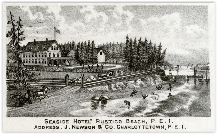
Seaside Hotel 1880. Meacham’s Atlas
One of the earliest of these hotels was at Rustico where John Newson operated the Seaside Hotel. The hotel faced across the mouth of the Clyde River towards the fishing port of North Rustico and had its main bathing beach just across the channel at Robinson’s Island where bathing houses were located. The hotel had been opened in the 1860s but really began to thrive after 1874 when the railway opened a station in Hunter River which meant that the resort was only a short carriage ride away along the Clyde River road which was crossed the river at New Glasgow and continued to Anglo Rustico.
On the Road, North Shore to Hunter River. Valentine postcard # 100,927
While there seem to be few photos of the hotel itself there are photographs from the surrounding area dating from the early 1900s. The route from Hunter River to Anglo Rustico is seen in a photo taken was one approached New Glasgow which dates from the first years of the 20th century. Showing neat stone walls and trimmed spruce hedges it is a superb example of tourist promotional material of the period. Another image from the period which also appears in a Valentine & Sons card is from a little further along the road between New Glasgow and Anglo Rustico where the Clyde River can be seen meandering in the background of a striking farmhouse high atop a hill on the south side of the river.
An Island Home, Prince Edward Island. Valentine postcard #100,920
The location of this image was hard to determine until Phil Culhane, another PEI postcard collector posted a question on-line and the crowd-sourced responses showed the building was still standing and is easily recognizable in size and shape (albeit with some unfortunate window replacement) and is located on the Dickeson property near what was in 1880 called Doironts Creek. Although the trees around the property now obscure the view of the river it is without doubt the same property as in the Valentine postcard. This photo continued to be published in both black and white and colour versions for many years and served as the quintessential Island farmstead image.
There was another postcard image from the same series actually taken from the Seaside Hotel looking north over a white rail fence looking toward the fishing stations on the sandbar at the entrance to what was then Grand Rustico Harbour. (Little Rustico harbour was at the other end of Robinson’s Island.)
Rustico Beach, Prince Edward Island. Valentine postcard # 100,928Detail of Lot 24 Meacham’s Atlas 1880 showing Seaside Hotel.
The Seaside Hotel was totally consumed by fire in January of 1906 and had not been in operation for the previous two years but before that it had been regarded as one of the most significant and successful of the Island’s summer resort destinations. Could the mysterious “North Shore” postcard be related to the three other postcard images in the series which came from the same general area?
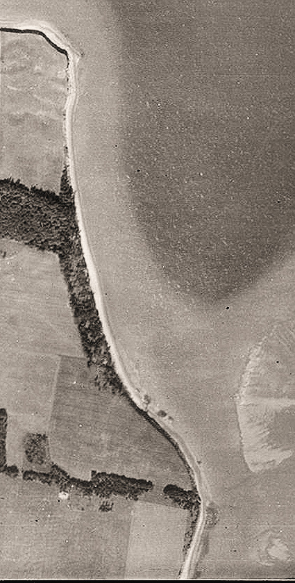
There were a few possible clues in the postcard image itself which relate to the site of the Seaside Hotel. If, instead of looking north towards Rustico one turned to the west what would one see? There was a slight indentation in the shoreline in the middle of which in 1880 a trackway came through the Benjamin Buntain farm down to the shore and around the point to the hotel wharf. In the North Shore card a similar trackway can be seen emerging from the woods. Further, if one looked across the point towards the north shore of the Clyde River a number of farms could be seen near the crest of the hill.
Detail from 1936 aerial photo showing woodland coverage.
In the 1936 aerial photo of the area, taken some thirty or more years later, the wooded land is similar to the postcard image with woods following the slope towards the unwooded point of land. There even seems to be a small outcropping of rocks in the same location in both views.
A recent visit made to the point where the Seaside Hotel once stood to the point shows many changes. The previously open fields and wooded areas of the Buntain farm have been built over with cottage lots and there has no doubt been some erosion of the points at both ends of the stretch of beach making it impossible take a photo from the exact same location as the postcard image. Even the state of the tide can make views of the same spot seem unalike.
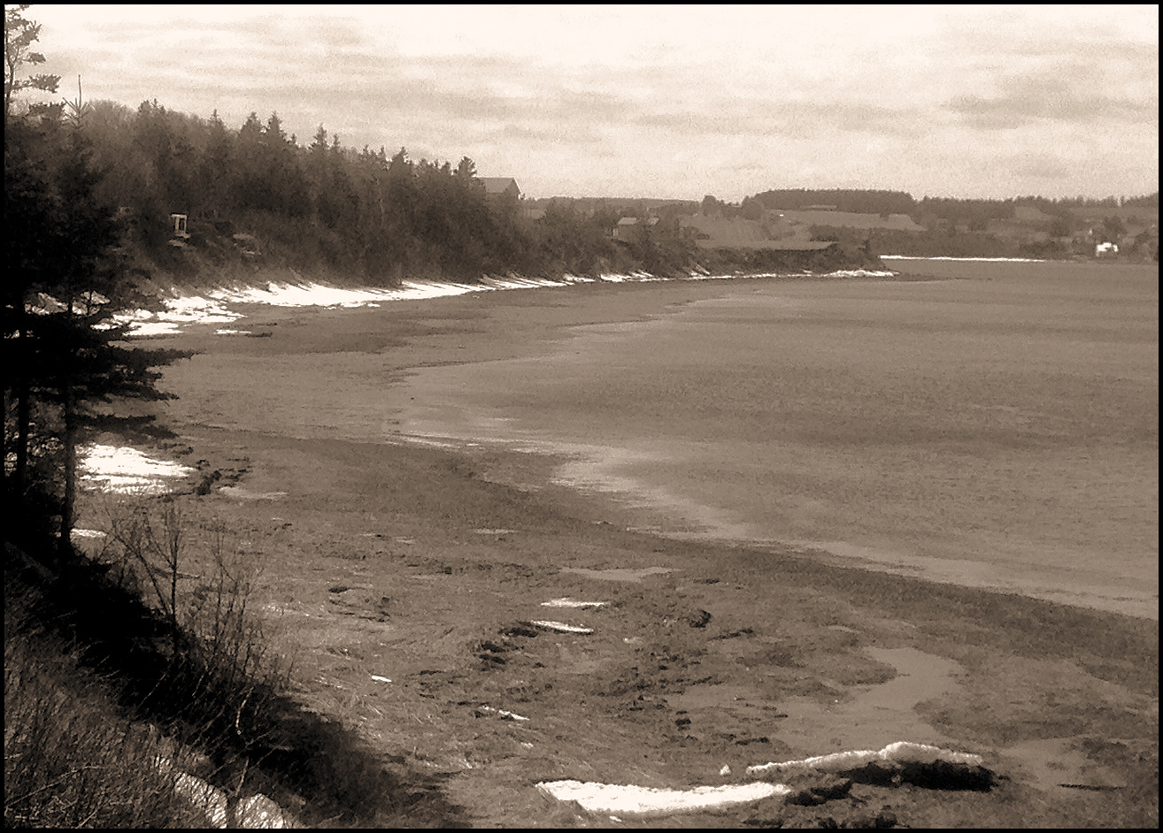
That being said, the present-day photograph shown below still shows some striking similarities between the view today and the postcard image from more than century earlier. The pattern of vegetation, with a surviving thicket of spruces coupled with a treeless point seems to have persisted over a century. That along with with the view across the river toward the north shore of the Clyde, the similar curve of the beach and cliffs, and the existence of other photos from the same tourist region popular in the 1900s make it highly probable that the site of the postcard image has been located as South Rustico, Lot 24, 46.44.56 North, 63.29.18 West. Prince Edward Island.
North Shore. Prince Edward Island. March 2021. Photo by the author.
I have recently been looking at the early Valentine and Sons view post cards of Prince Edward Island, especially the two series that the company did for the Inter-Colonial and Prince Edward Island Railway which I explored in an earlier posting. A closer look at some of these cards has thrown up an interesting variant series (or perhaps two).
Typical Valentine Black and White image but lacking the characteristic reference to the Inter-Colonial and Prince Edward Island Railway. The reference appears on neither the front nor the back of the card.
These monochrome cards have the white card-bottom stripe with the title but without the railway reference. However a bigger surprise is to be found on the card back.
Card backs showing McCoy and Archambault overprints
These cards have an overprint of the publisher credit, in some case completely obscuring the “Valentine Series (Britain)” wording, but more frequently showing the Valentine information as well as that of another publisher. Most of the P.E.I. cards that I have found have the words “McCoy Printing Company, Moncton, N.B.” as seen in the above illustration. In Mike Smith and William Angley’s 2010 volume McCoy Printing Company Picture Postcard Handbook 1900-1910, seven items are listed as McCoy cards using the Valentine image numbers which also appear in the railway series. Several additional cards with this format have been found and it now appears that at least nine of the Valentine images appear with the McCoy overprint and it is probable that, as with the colour series, all ten of the cards appeared in this alternate format. Use of Valentine images, complete with image numbers, by other publishers is not uncommon but this is a clear indication that Valentine may have actually been the publisher for some of these other series.
What is somewhat surprising is that McCoy may not have been the only publisher which took advantage of these early Valentine cards. At least one card (again seen above) bears the words “R. Archambault, P.O. Box 108, Montreal” In this case the wording appears on the back of the “Near Souris” card with Valentine image # 100,925, illustrated at the head of this posting
I am not aware of any other P.E.I. cards with this Archambault imprint or credit. Was this a “one-off” or is there yet another ten-card series with the Valentine images out there somewhere? Having looked only at P.E.I. cards it is difficult to state whether or not this publisher mixing and matching was common elsewhere.
The impressive number of Valentine cards now has another collecting dimension as more variant series are identified.
Valentine and Sons (later Valentine-Black) was the largest publisher of postcards in Canada. Between 1905 and 1964 when they ceased business, they issued more than 12,000 postcards. Of these, over 140 were of different Prince Edward Island scenes and the Valentine cards document the Island over almost sixty years.
Fortune Harbour, image # 100,925
In the earliest years Valentine had a unique arrangement which saw them produce a series of view cards co-labeled with the Intercolonial and Prince Edward Island Railway. Although both lines were operated by the Government of Canada they each maintained a somewhat independent identity. The Intercolonial was very active in the promotion of tourist travel and a number of guidebooks touted travel to the area served by the government lines.
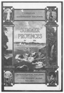
Cover of Summer Provinces by the Sea
These guidebooks were well written and well-illustrated. The most well-known was Summer Provinces by the Sea which contained a large number of PEI views from photographer W.S. Louson, who also supplied many postcard images to Warwick Bros. & Rutter. Postcards were a natural fit for the promotion-minded railroad and Valentine published two series bearing the names of the companies.
These series seem both to have been issued in the same year, 1906. The listing of image numbers for the Valentine company shows a total of 10 photographs for this set of Prince Edward Island postcards. The black and white images are clear and all depict rural scenes already associated with the themes of landscape and leisure activities. Interestingly the scene on only one of the cards, Morell River, is actually on the line of the Prince Edward Island Railway.
Card back used for Valentine railway black and white cards.
These cards have a white title band at the bottom of the card with the words Intercolonial and Prince Edward Island Railway. The back of these cards was a standard Valentine design for the period. The divided back card was headed Souvenir Post Card while the words “Valentine Series (British)” are on the left edge.
Black and White cards. Click on any image for larger view.
An Island Home #100,920
Dunk River #100,921
Hampton #100,922
Pastoral Scene # 100,923
Scene Near Souris #100,925
Morrell #100,926
North Shore Road #100,927
Rustico # 100,928
North Shore # 100,919
Several of the scenes continued to be used by Valentine for several years but without the railway connection. Most of the scenes can be located: Rustico, Morell, Dunk River, Hampton Beach, and the road between New Glasgow and Hunter River. One card labeled “Near Souris” is actually Fortune Harbour, and a “Pastoral Scene” is, with little doubt, where the Green Road crosses the Eliott River near Crosby’s Mills. It is more difficult to place the other cards. The Island Home could be one of several places on the north shore estuaries, while the North Shore beach is extremely difficult to place – if you look closely you can see several farms in the background on the extreme right of the card.
Fortune Harbour image #100925 colour series
There was also a coloured series with the same scenes but with an additional card depicting a wildflower field overlooking Pownal Bay. (Spelled “Pownall” on the card)
Colour cards. Click on any image for larger view.
On the Road, North Shore to Hunter River # 100,927
An Island Home # 100,925
Rustico Beach # 100,928
Near Souris # 100,925
North Shore # 100,919
Pastoral Scene # 100,923
Hampton Beach # 100,922
Pownall Bay # 100,924
Trout Fishing Dunk River # 100,921
Morrell River # 100,926
These cards lack the bottom white band but the left hand side of the card back provides the information linking the cards with the two railways . The remainder of the card back is the same as the back for the black and white cards.
Card information on left side of back.
The fact that there are ten cards listed in the table of image numbers and that ten colour cards have been found suggests that there is an additional black and white card depicting the field overlooking Pownal Bay which does not appear in on-line collections. I would be interested in hearing from any collectors who have seen such a card or who can provide location information for the cards titled “An Island Home Scene” or “North Shore.”
Several of the cards illustrated are from images from Phil Culhane’s excellent PEI postcard web site found here.

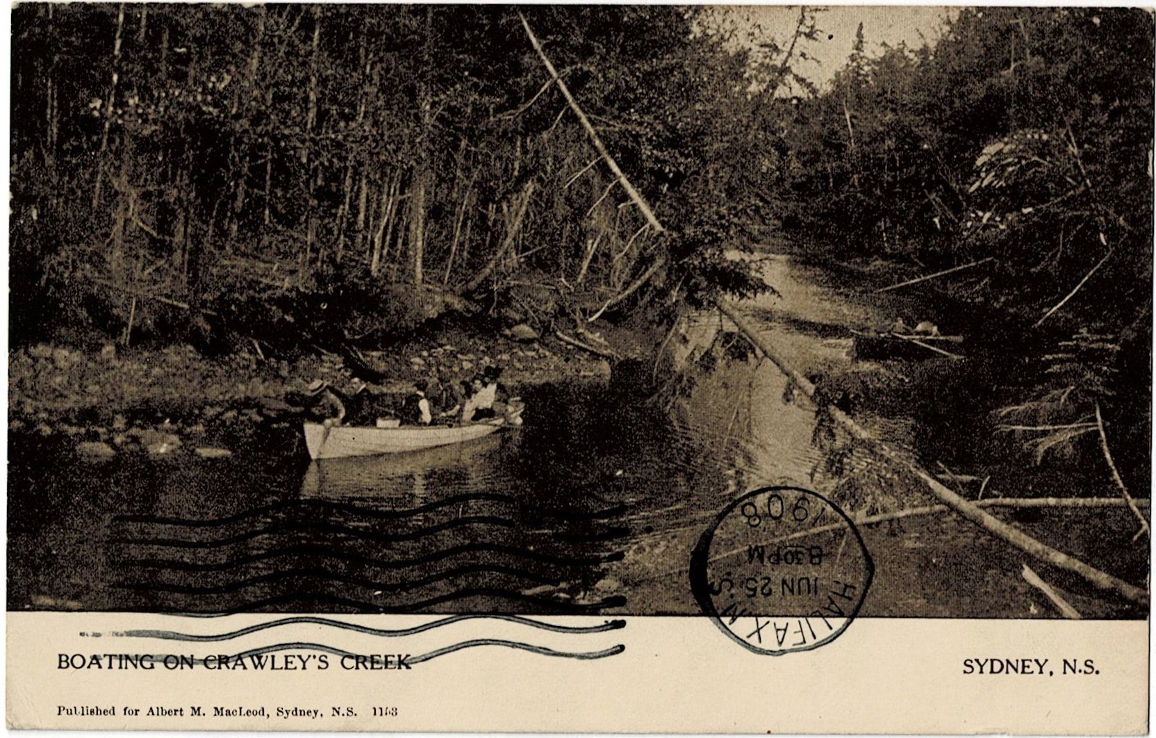 His posting also contained a number of Crawley Creek cards which confirmed that the Sydney location was correct and that the river was most assuredly not the Morell.
 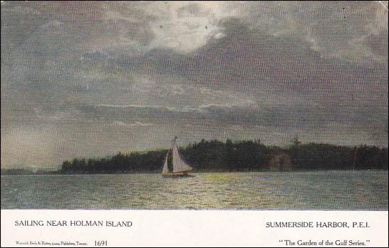 While Warwick Brothers & Rutter were not the only firm to use the same cards for multiple locations it happened too frequently for it yo be simply a filing accident. I have written about several other W&R mis-locations in previous postings. A P.E.I. fishing scene was appropriated for use as the Humber River near Toronto as seen here, and, perhaps in a spirit of atonement, an Ontario waterfront became confused with Charlottetown Harbour here. Another double location card (shown above) is variously titled “An Evening on Blair’s Lake, Amherst and Sailing near Holman Island, Summerside Harbour.”
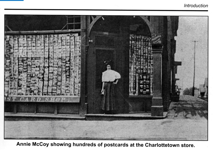
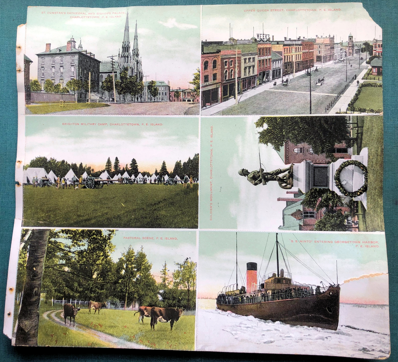 A typical page shows an almost random placement of the cards with vertical and horizontal cards on the same page. Closer examination revealed the perforations between the cards making it easy to remove any or all cards.
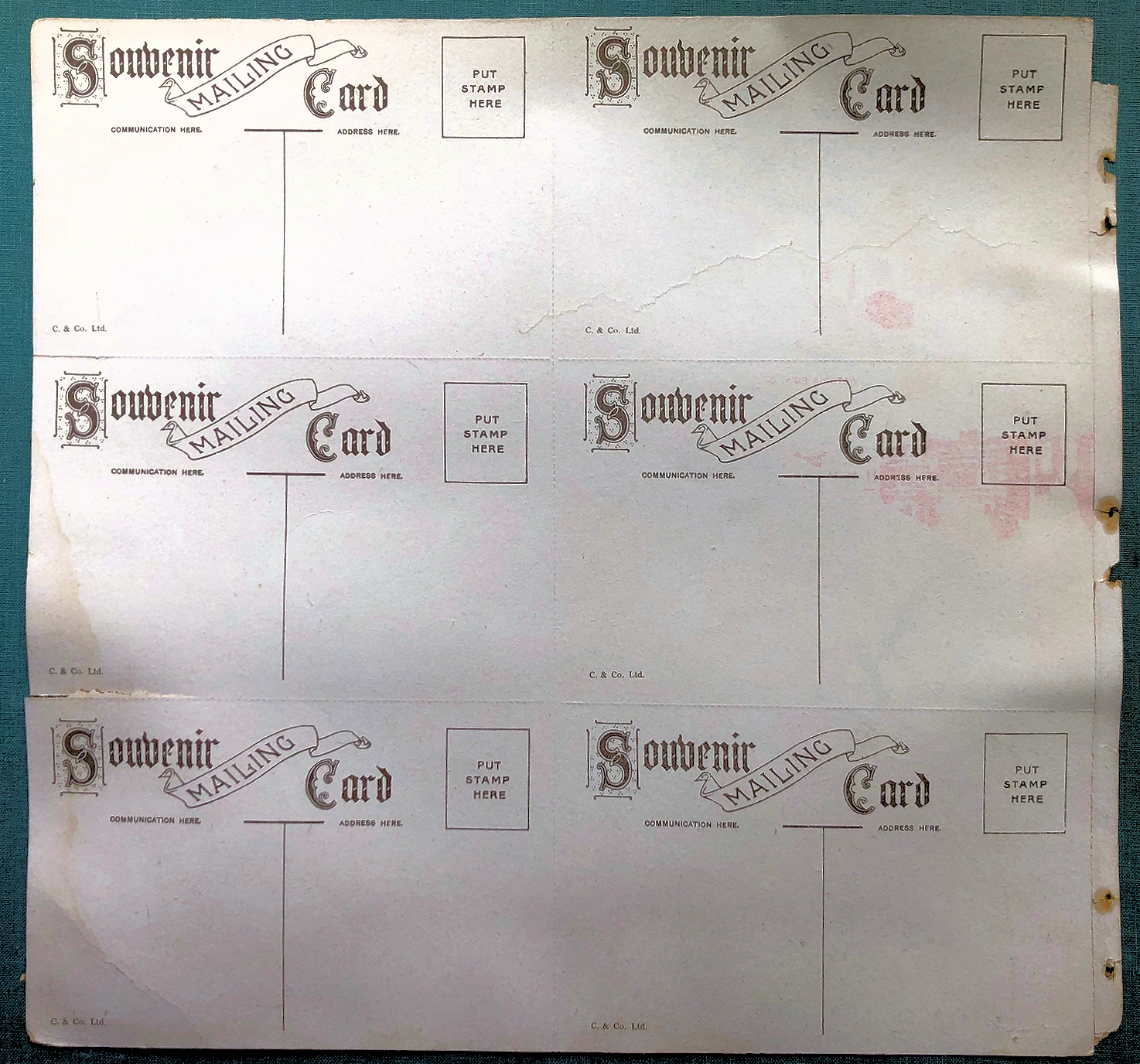
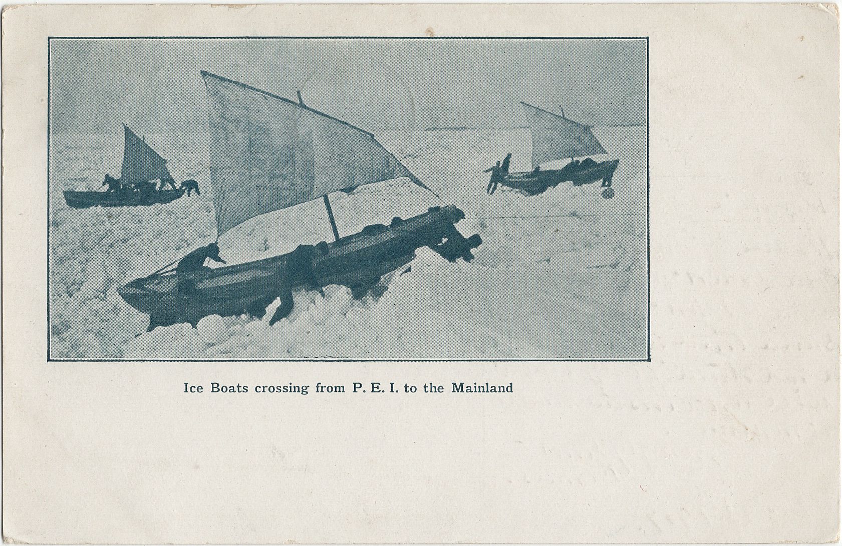
 It is always gratifying to put names to images. Such is the case with regard to the undated card shown above. This early divided-back card shows a dramatic scene with crews struggling to bring iceboats across a field of jammed ice or thick “lolly.” Unusually the boats are show with their small lug sails in use. These were only deployed when wind speed and direction were favourable. The photo is not particularly crisp and the quality of the reproduction poor but it is one of the earliest postcards to show the scene which was unique to the winter service on Prince Edward Island.
 In researching the history of the iceboat service I stumbled across the same image, hiding in plain sight, with the identity of the photographer credited. In April 1903 the Prince Edward Island Magazine published an illustrated article titled “Our Winter Navigation.” (
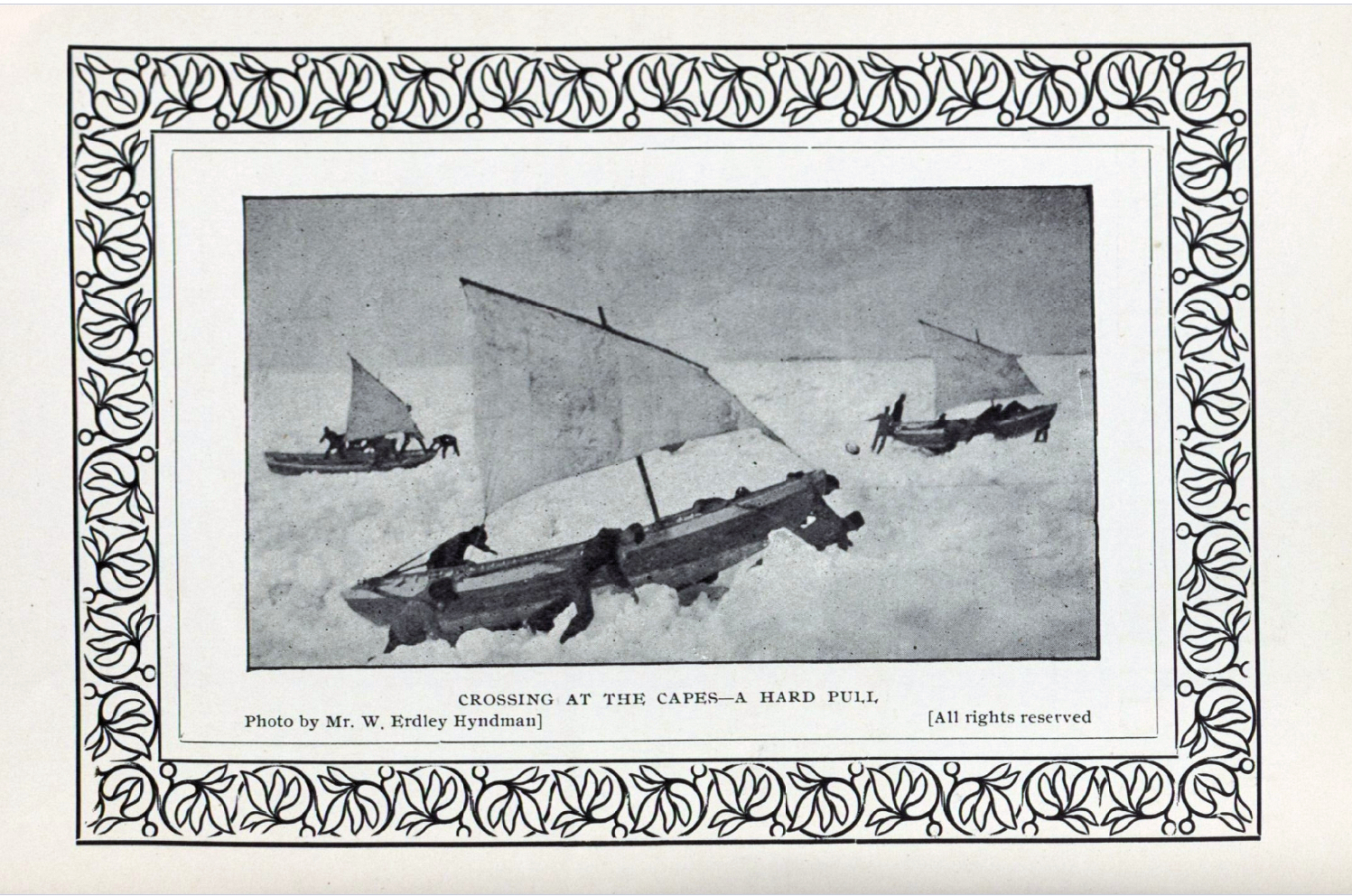
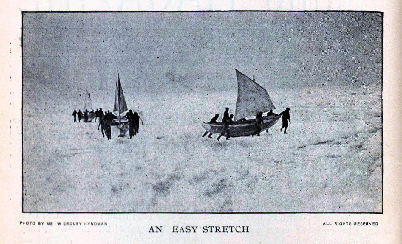 As well, there seem to be other images which may well have been taken by Hyndman the same day which were not included in the Prince Edward Island Magazine article. This is the case with “An Easy Stretch.” Other iceboat cards also appear to have used images which were taken by Hyndman although no credit is given. The card below, “Crossing to Prince Edward Island in Winter,” was sold by Taylor’s Bookstore and given the style, title type-face and subject certainly seems to be part of the same series although the card is monotone image.
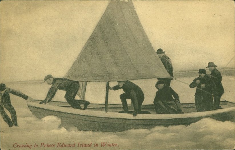
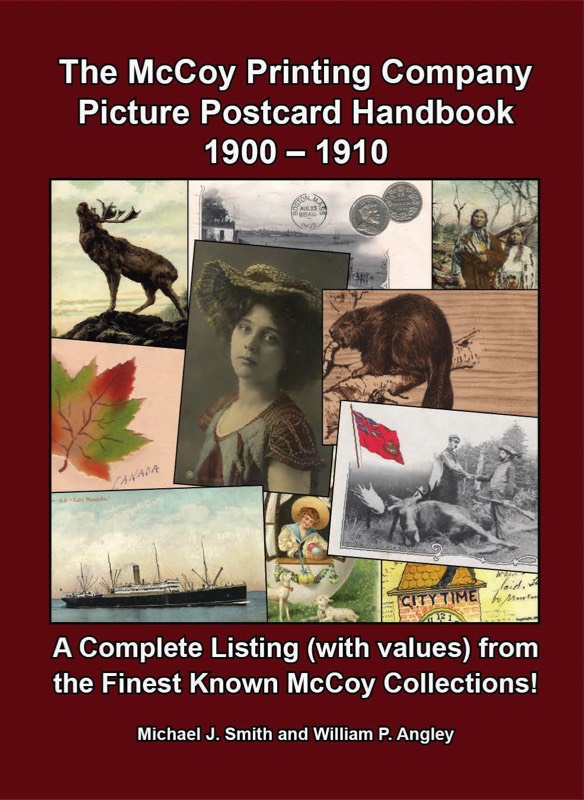 Among the excellent resources for post card collectors are the series of guidebooks published by Mike Smith. One of these, The McCoy Printing Company Picture Postcard Handbook 1900 – 1910, by Michael J. Smith and William P. Angley, documents the postcard activities of the McCoy firm which was located in Moncton, New Brunswick. Among the hundreds if not thousands in cards the volume records some fifty McCoy postcards with Prince Edward Island images. Although a few additional P.E.I. cards have been found since its publication in 2009 it remains the “go-to” guide for McCoy postcards. Unfortunately the book is no longer in print and used copies are rare .
 Eight of these photographs appear in an undated publication by Swan which, from internal evidence, appears to date from 1904. This album, Through the Maritime Provinces (New Brunswick and Nova Scotia) By J. Wesley Swan, Montreal includes images which continued for decades afterwards to be emblematic of rural Prince Edward Island. The brief introduction notes “The views shown are reproductions from direct photographs made by the publisher and are only available through this channel.”