

Charlottetown’s Victoria Park was established in 1875. It was carved from a property on the western side of the city designated as the Governor’s Farm. When Charlottetown was laid out it had five squares: Queens, Kings, Pownal, Hillsborough and Rochford. By the mid 1800s these were becoming inadequate to the city’s needs. Queens Square was occupied by the market and other public buildings, Pownal Square housed the city jail. A chance to set aside public space on the waterfront was lost when the Imperial government gave up the ordnance grounds at the west end of Water Street. The colonial authorities decided to auction the lots off instead of establishing a park. The possibility of turning over part of the Governor’s Farm for a park was raised in 1869 and was discussed during the negotiations leading to the Island’s entry into Confederation.
Finally in 1875 40 acres constituting the westernmost part of the farm were handed over to the city. The grant excluded the Prince Edward Battery which was retained for military uses. By 1880 the field nearest the harbour was identified as a cricket ground and one near Brighton Road (now Memorial Field) became a parade ground for the several military units in the city. Access to the park was from Brighton Road because the proposed roadway extending Kent Street in front of Government House was opposed by various Lieutenant Governors until 1896. The roadway to the Battery was completed a year later and was extended to join Brighton Road in 1899. In 1905 additional land was carved out of the Government House Farm and the Park reached the size it has today.
As the premier recreational space the Park was the subject of many postcards highlighting the natural setting and the activities which took place there. First and foremost it provided a vantage point of the harbour with the open channel to Hillsborough Bay.

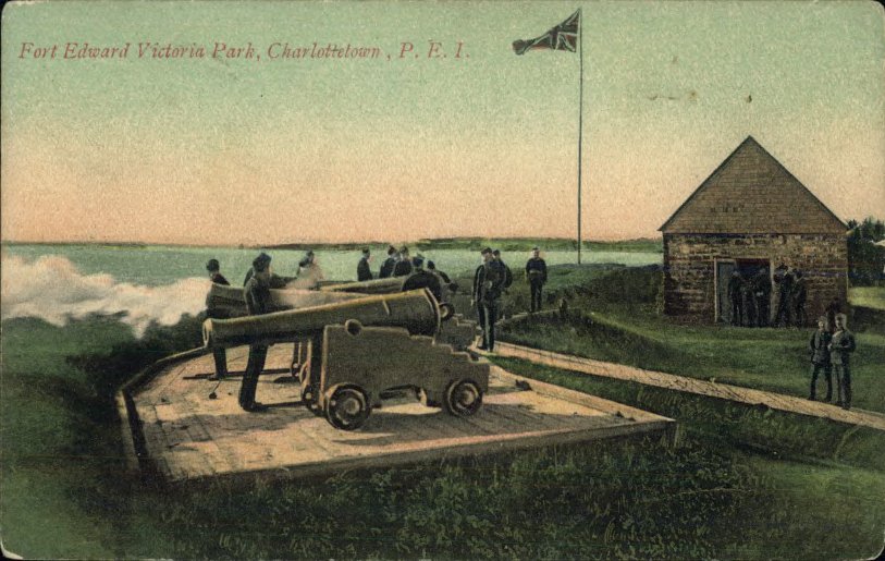
An extremely popular postcard subject was the view from the Prince Edward Battery (usually misidentified as Fort Edward) back toward the city. A single image was used by a number of publishers and others appeared which were only slight variations of the view.
In the early 1900s the military installation was still very much in use. The main army drill hall and other structures were on the east side of Governor’s Pond. The Battery was used by the artillery for both training and ceremonial uses. The 4th Artillery Regiment was particularly successful in Dominion competition and frequently led the country in the national results.

The annual Militia camps took place in the park until the Great War and provided an entertainment for visitors and residents of Charlottetown. Militia groups came from across the Island to set up camp in the Park and engaged in drills and competition while under canvas. The patriotism of the Boer War period made membership in the militia a popular form of comradeship and interest in civilian soldiers continued through to the Great War.


But military camps were not the only users of the park. Although there were limitations on the use of the park for shows and commercial activities which had a paid admission charge, community groups were frequent users.

The vast majority of the early postcards images of Victoria Park deal with the natural views in the park. A number of carriage lanes, some still in use as pathways today, had been opened in the predominantly birch forest and the striking groves of white birches served as both subject and background for Charlottetown photographers. W.S. Louson, whose photos were used by the Toronto postcard firm Warwick Bros. & Rutter was particularly enamoured by the park as a photo venue. [click an image to enlarge or begin slide show]


Today Victoria Park continues to be the site of postcard views and increased use of the park had led to more and more structures; fieldhouses, a bandshell, and changing rooms. During the Edwardian era the only buildings were the battery magazine, the tennis pavilion and the keepers house. Now it becoming overbuilt and is harder and harder to pretend, as our ancestors did in the beginning of the 20th century, that the park represents a bit of the country in the city.

I found this deeply interesting and very valuable in helping to sort out the history of Victoria Park. Your postcards are remarkably fine with good detail and colour. Thank you for this. I wondered why you did not include the postcard showing the bandstand and, in the distance, the WW I hospital? I would very much like to read what you have to say about that.
LikeLike
I order to put limits on the scope of the blog I have arbitrarily decided to restrict the discussion and images to the pre-war period. This makes it essentially very late Victorian and Edwardian. I have an image of the card you reference and almost included it until I realized the MacLean hospital (post-war) was in the image. Most postcard collectors agree that the “golden age” of postcards ended about 1912 or so. I am struck by the richness of the postcard images of PEI for the period. Perhaps someday I will have said as much as I can about the Edwardian island and will move into the next decade.
LikeLike
Again the historical details you provide are very interesting and helpful to me to understand the history of the City and this park.
LikeLike